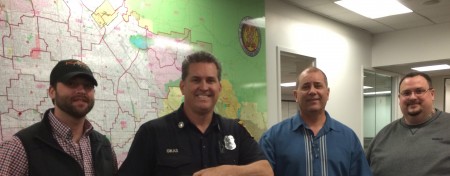
 From Left to Right: Delta State's GIS program affiliate Ryan Poe, Captain Tom Gikas from L.A. City Fire Station #78, Captain Yo Gikas from L.A. City Fire Communications Division and Talbot Brooks, Director of the GIT Center at Delta State at the City Emergency Operations Center in downtown L.A.
The Center for Interdisciplinary Geospatial Information Technologies completed a two-day training course regarding the U.S. National Grid (USNG) for the Los Angeles City Fire Dept earlier this week.
The USNG provides a means to locate emergencies when emergency responders have a difficult time finding an incident. Approximately one-third of all emergency calls do not occur at a street address, and this often results in delayed response times. L.A. City Fire and many surrounding emergency response agencies plan to incorporate USNG into their dispatch and mapping systems for use by responders.
While in Los Angeles, Director of the GIT Center Talbot Brooks and GIT Project Manager Ryan Poe were guests at L.A. City Fire Station #78 in Studio City and spent some time riding out on fire calls.
“The need to use USNG was one of our lessons learned from Katrina. It has the potential to save thousands of lives should LA get hit by the “Big One” and street signs and house numbers become unreadable. Having first responders able to read maps and navigate using coordinates will make a tremendous difference,” said Brooks.
For more information on the Center for Interdisciplinary Geospatial Information Technologies, please visit the website or call 662-588-8649.